


When we talk about future development essentially the discussion is about additional housing. The current Local Plan target for more housing in Tarvin Parish in the period 2010-2030 was for a minimum of 200 dwellings. This was in fact achieved by 2017.
This situation emphasises why a Neighbourhood Plan is so important as without it the area could be the subject to pressure from developers. This is already a reality as in 2016 two developers published outline proposals for around 106 dwellings with one application in the Green Belt. The community was strongly against these proposals and hence it is crucial that the views of the Community, as expressed in the Neighbourhood Plan , are central to any future development.
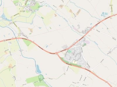
Currently no settlement boundary exists for the village of Tarvin. In the Summer of 2016 CWaC proposed a boundary drawn very tightly around the developed area of Tarvin village.http://local.4291574( See here.
) The Steering Group support this proposal because until and unless community infrastructure i.e. roads, village parking, access to health provision and recreation are improved further housing would exacerbate the already strained current situation.
Why is this significant?
The boundary determines the edge of the village for the purpose of Planning policy. Outside the boundary land is treated as countryside and therefore subject to restrictive planning policies for development.
The Local Plan (Part 1) states that within the countryside the following developments are permitted:
- Development that has an operational need for a countryside location e.g.farming and forestry
- Replacement buildings
- small scale and low impact/farm diversification schemes appropriate to the site, location and setting in the area.
- Re-use of existing rural buildings, particularly for economic purposes, where buildings are permanent constructions and re-use can be achieved without major construction.
- Expansion of existing buildings to facilitate growth of established businesses proportionate to the nature and scale of the site and its setting
Beyond 2030?
The Steering Group feels that the only area where significant (defined as 6 houses or more) additional housing should be sited is on land east of Tarporley Road/ Church Street due to the proximity to local amenities and services with the proviso that existing infrastructure deficiencies are overcome and also:
- Housing was of the right type to meet local community needs e.g. affordable, for rent and to enable existing residents to downsize.
- The scale, design and layout of any development recognised the importance of the views from Tarvin towards Kelsall hill and from Oscroft towards Tarvin.
- A substantial settlement gap between Tarvin and Oscroft was preserved.
- The impact on wildlife corridors and other sensitive environmental conditions was minimed
- Improved leisure facilities are provided unless they have already been delivered in the interim.
Quick Links
Get In Touch
TarvinOnline is powered by our active community.
Please send us your news and views.