Bridge detective 2: Hockenhull bridge


Farndon bridge over the R.Dee imposing as it is shares some features with the Platts bridges. Each held an historic river crossing and both were on packhorse routes. They still share a design feature in the triangular bridge supports and perhaps, not for the same reason, yet still a matter of debate.
On Farndon bridge the supports or cutwaters are there to deflect floodwater damaging the structure. Why does a similar feature occur on Hockenhull bridge and on the wrong side of the bridge to the flow of the former Gowy? Originally, it was considered to be a buttress added to support the bridge. However, close inspection shows it not an addition but part of the bridge structure when it was rebuilt.
Nevertheless, the largely hidden cutwater feature can still be seen. Apparently, medieval bridges, even small ones, had cutwaters on the opposite side to the flow to prevent 'scouring', where the water was turbulent enough to erode the river bed and undermine the bridge.
This suggests the Gowy was even a more powerful river in medieval times. Also, it lends support to a very early bridge when the Gowy was east of its present course.
More features of interest.
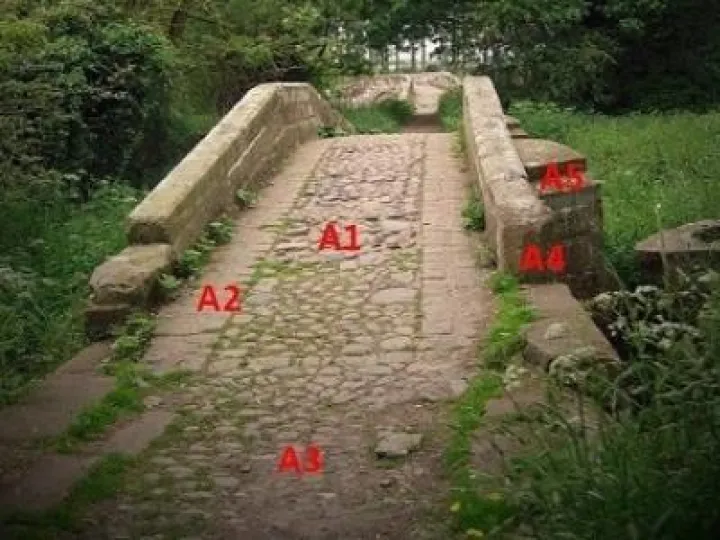
A1: This hard-wearing cobbled central section of the deck is common to all three bridges. It will have been repaired often as evidenced by some variation in stone size. Even so the surface is the most complete of all the bridges and might well suggest how the surface looked when the bridges were built in the 17th century. The origin of the marble-like cobbles and indeed, the sandstone blocks is not known at present.
Cobbles, perhaps replaced flagstones, to withstand the passage of trains of packhorses. In upland areas their journeys would be over difficult terrain with paving of some kind ('causeys') defining many routes.
A2: Granite setts mark two lines either side of the cobbles and again, feature on all the bridges. No record offers any reason for their purpose until now.
Originally, the bridge had no parapets only a kerbstone edging as in the Acton bridge mentioned earlier. A bridge width of almost 2 metres was more than enough for a single line of packhorses and entirely suitable for carts and wagons. The sett tracks allowed wheeled vehicles to cross. With the addition of parapets (A4 above) a medieval cart could just cross over. Packhorses with large panniers could not once the parapets were more than a sandstone block high.
A3: No record exists of this being part of a causeway extending any distance up Platts Lane. A causeway does connect Hockenhull bridge with the middle bridge and will be in detailed
A4: Parapets are a later addition to the bridges. As the bridge deck was resurfaced the nearest course is partly hidden.
The sandstone blocks used are large with those at the base of the buttress (D) larger still with a massive angular block at (E). This bridge shows the most structural stress. The wing wall at (C) is tilted from the line of the causeway. The two courses above A to B are likely additions. The buttresses, the wing wall, the parapets and other minor stress points imply the bridge shows signs of instability. It may be due solely to the action of a historically more powerful R.Gowy, coupled with seasonal floodwater, or its foundations do not rest on bedrock. Once the site of a 14th century bridge, its failure by the early 17th century could be attributed to rebuilding, with supports, in the same place.
Today, the ground below the arch shows many decades of sediment. Only a trickle of water, not a river, passes beneath it. When the river stopped flowing is a matter of more study.
Next: The Causeway
Any comments please: [email protected]
Quick Links
Get In Touch
TarvinOnline is powered by our active community.
Please send us your news and views.