Crossing Hockenhull Platts marshes.


The aim is to offer the possible means used over many centuries to cross the Platts marshes. It suggests a storyline for the creation of the historic routeway at Hockenhull. The bridges are the end result but it is the river landscape, the marshes, and, above all, the prehistoric people that set the pattern for thousands of years. However, there is little evidence apart from logs during work on the middle bridge in the 1940's. A hidden causeway might well be ancient and there is some support for the Romans being at the Platts.
Marshes were once far more extensive along the Gowy valley. Land reclamation by draining, straightening and embanking the river has d reduced these wetlands. This happened at various times in the past but mainly in medieval times. Such changes to the landscape were driven by the demands of cereal farming. The annual flooding of the river restricted such crops to the drier slopes. However, the number of mills along the Gowy and its tributaries is evidence of the once importance of cereal crops.
At Hockenhull, a small area managed by Cheshire Wildlife Trust remains. A much larger area, never considered, south of the bridges on the Hockenhull bank was created by the former course of the Gowy and stretches down to Guy Lane. The floodplain along the Tarvin side show the features of the old course of the river; abandoned meanders, ox-bow lakes, old channels and extensive reed beds.
[Of elm and oak
]
For thousands of years people crossed the Platts using suitable materials and technologies. Mostly they just waded across or used a timber walkway set between thick posts. Canoes would be launched from the end of the walkway where stones laid on the bed of the river created a ford. Unsurprisingly, very few such walkways or canoes have been found. The few walkways excavated in marshes were made of elm or oak as were dug-out canoes like one found at Stamford Bridge in the 1911. Might Hockenhull have had its share of such canoes, even a walkway?
A proper causeway
By the late Iron Age, a causeway, initially of logs a few metres wide, was improved with flat stones laid upon a layer of brushwood topped with soil. Thick logs formed a strong, stable platform extending as a bridge over the river itself. The Gowy being a wider, faster river, some form of bridge was needed to cope with the river in flood.
Of stone and timberIMG(405324,S,L)
Later, a stronger crossing was constructed approached by a hard surface of cobbles, gravels or paving topped with soil or sand. Such a form was used for a time by the Romans at Stamford Bridge in building Watling Street; it was replaced by a stone bridge. Chester had two successive timber bridges each set on stone piers as did other settlements such as Warrington, Nantwich and Farndon.
If a Roman bridge did cross the Platts no trace would exist unless its timber (or even concrete) supports remain under the marshes. What does remain is the question? At present it seems reasonable to believe the original stone causeway (largely hidden) at the Platts may be of pre-Roman origin.
[A causeway of stone
] Described in the article Causeway 2 but here a different thought presents itself as it suggests the latest stone crossing of the Platts. It ties in with a medieval paved track or 'causey' along a hollow way seen elsewhere in Britain. Did Platts Lane look like this? If it did was it more than a trade route for packhorses?
The Middle Ages were a time of great upheaval with much warring at home and abroad. A time when supplies for maintaining the Norman lords and their armies was at its peak. Was this the reason for building a solid causeway across the Platts both as a military and trade route? It would have generated serious growth in the packhorse trade. A trade which sustained the economy of the country through to the 19th century.
At this point today's causeway is considered. It requires a serious leap into the unknown until, if ever, documentary or, even more unlikely, archaeological minds, give a better outcome.
Fact. There is a causeway across the Platts. It is hidden to the middle bridge and there is a later, raised one, between the middle bridge and Hockenhull bridge. My contention is the earlier causeway crossed the whole width of the Platts so how might it have looked before Ogilby's map showed three bridges in 1675?
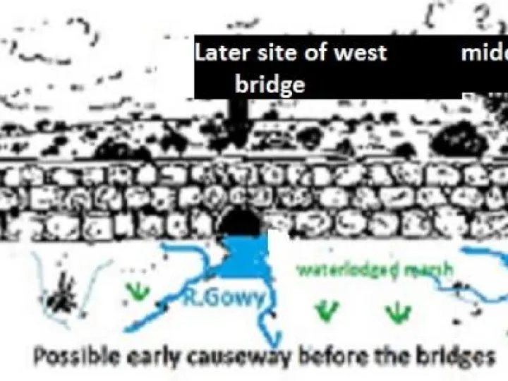
It would be sandstone, about 2 metres above and below ground and the same in width possibly set on the bedrock. Indeed, both the depth of the marsh and river are on the underlaying bedrock and partly control the character of both in maintaining a high water-table.
Materials for the west and middle bridges were moved along this causeway as suggested in Causeway 2. Here, the illustration shows the bridges at two possible places where the Gowy and a tributary passed through the causeway. The exact position of the Gowy is difficult to be sure about as is the date of the causeway. It could be medieval in keeping with Hockenhull mill dating from the late 13th century. To support the mill the Gowy had to flow through the east bridge. At this stage it is best left to when the story of the Gowy itself is considered. For such a small river, unpicking its movement is a very real challenge.
..........................................
Any feedback to [email protected]
Quick Links
Get In Touch
TarvinOnline is powered by our active community.
Please send us your news and views.