The Platts Bridges: A Roman legacy?


This article aims to provide evidence to challenge the claims that carts did not cross the bridges because they were too narrow.
.......................................
How did the design of the bridges come about?
There is no recorded evidence to suggest there were bridges of any kind before the 11th century. The assumption is there were and they crossed the Gowy marshes at the Platts; both are open to question.
Historically, a causeway and ford were the means of passage until there was a need for a bridge. Might this bridge, governed by the width of the causeway, have determined bridge design then and for many centuries thereafter?
Is the pathway width of the Platts bridges based on a Celtic raised timber causeway and bridge, a Roman bridge, a Saxon one, a plat bridge, the width of a loaded packhorse or the everyday cart width used by the Normans in building the first sandstone bridge.
Some 800 years before the Romans invaded Britain, Celts were using wooden wheeled vehicles. Their technology was advanced enough to build causeways, bridges and roads and other impressive engineering projects. They were likely to have used the Platts route, perhaps made the route, to reach the Cheshire salt deposits at Northwich. In so doing might the Celts have laid the basis for what was to last over 2000 years or was it a Roman legacy?
Romans employed Celtic trackways both for laying down a number of main, military and minor roads using their own methods and measures. Such engineering required a variety of carts and wagons.
'Altogether, a range of vehicles was created in the Roman era that would satisfy the needs of European society for the next thousand years'
Carts (both handcarts and horse drawn) were one of these vehicles, with an axle width of 1.5m (4ft 9in) and wagons about 1.8m (5ft 9in) may offer another perspective on the design of the bridges.
In 1885, a section of Roman road excavated near Eddisbury Hill fort in Delamere was shown to have wheel ruts giving an axle width of 1.5m (4ft 9in). This is the same pathway width as the present day Platts bridges.
Was there a Roman bridge at the Platts with a width of at least 1.5m and did it become the standard width thereafter?
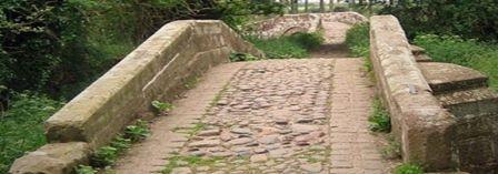
The accepted record maintains purpose-built packhorse bridges by virtue of their design. Were they built according to what went before or based on a contemporary design? Whatever their origin the Platts route was at some point in time, described as busy as any route outside London. Yet, the narrowness of the bridges and Platts Lane must have been a nightmare to pass through.
Packhorses bridges had a very low parapet or none at all. With a single low parapet carts and wagons were able to cross as the axle would not be obstructed. Without parapets, the Platts bridges would be 1.9m (6ft 9in) and easily wide enough for carts. The parapets of today would not permit either packhorses or carts to cross. If these 17th century bridges were built with higher parapets then the packhorse trade was over. If not, the bridges were modified later but not for the prospect of any other form of transport.
A bridge existed in the 14th century and three bridges in the 17th century but nothing, so far, suggests there were more bridges between these dates. The assumption that carts did not cross the bridges is mistaken, according to the one source:
'Back in the 17th century, Hockenhull Platts was a far wilder place even if it was on the main road. To stop the surface degenerating into a mire in winter, carts were prevented from using the road by posts set across it at intervals.'
Medieval carts passed across the bridges at least until the 17th century when today's bridges were built. How else would materials for bridge building be possible? Mention was made of carts being prevented from using Platts Lane. This might well suggest the alternative routes shown on Ogilby's map of 1675; see (a) and (b).
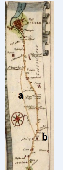
The ' Chester cartway' went via Tarvin to Chester and the second route to Chester through Duddon crossroads to Stapleford bridge to Waverton and Christleon. It is feasible a variety of wheeled transport crossed the Platts bridges as late as the 19th century or at least until the bridge parapets were raised. Perhaps, 1675 signalled the end of the packhorse trade with the turnpiking of roads and the coming of canals and railways.
The bridges were connected by a causeway. A contemporary one between the resurrected Hockenhull bridge and the central bridge, then continuing, as an earlier causeway to the west bridge. The re-alignment of the central bridge to connect to the old causeway leading to the west bridge is of interest. Did the line of this causeway end at a ford and required the later bridge to be aligned to it?
In considering how the design of the bridge originated has needed, as always, some lateral thinking. Hopefully, this has been positive and thought-provoking.
(Any feedback please: [email protected])
Quick Links
Get In Touch
TarvinOnline is powered by our active community.
Please send us your news and views.