
Hockenhull Bridge- It's history?


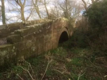
Of the three bridges across Hockenhull Platts, the east bridge, Hockenhull Bridge, is here regarded as both the most historic and individual of the three bridges.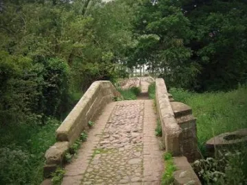
A century after the Norman Conquest there was a simple bridge over the Gowy. It was a timber structure judging by the place-name, le Plat, a plank bridge, according to Dodgson.
The Cheshire Sheaf suggests a sandstone bridge crossed the river in about the 12th century rather than being attributed to the 14th century based on place-name evidence.
In September,1353, in a rare visit to Chester, the Black Prince crossed the Gowy by this bridge.
It was in such poor condition that he granted 20 shillings for the 'repair of Hokenhull bridge. Such a significant amount indicates more of a rebuild than a repair. To set this in perspective, it might provide a stone mason and 5 labourers for two weeks; a mason earning 6d a day and a labourer 2d a day. We can conclude it was hardly, a simple repair.
Any bridge closure would be a major hindrance to both travellers and traders on this the King's Highway from London to Holyhead. Doubtless, the lucrative salt trade using the route from the Cheshire salt-fields had to be protected at all costs.
I maintain, the present day Hockenhull east bridge was the only bridge at the time of the Black Prince's grant. This is based on the course of the Gowy and the need for a bridge to access Hockenhull Mill.
The deterioration of the bridge continued until 1608 when at least some action was taken. The local Justices of the Peace ordered no bridge could be repaired or built and paid for by the county, until each had been examined. Six years later, Hockenhull bridge was still in a ruinous state and the Platts route to it under stress.
Back in the 17th century Hockenhull Platts was a far wilder place, even if it was a main road. To stop the surface degenerating into a mire in winter, carts were prevented from using the road by posts set across it at intervals.
The state of the bridge and route would have long been a serious hinderance to travel of all kinds particularly the packhorse trade and critically, the movement of salt. Hockenhull mill could hardly have served the local people who had, by law, to use the mill.
The situation was more than a local issue. Action came from the parish of Hockenhull in its forthright plea to the Justices in 1614:
"Showeth unto your worshipps that, whereas theire ys a place and Bryde called Hockenhull Platte which is soare decayed and so farre out of order...that a Collection maybe gathered in this County of Chester towards Building, repairing and amendying the said Bryde and highways"
The plea failed, for in 1621, William Webb wrote in his Itinerary of Eddisbury:
"At the one side of which demesne lies Hockenhull Plot, a place well-known being the passage over the said water, in our great London road-way to Chester, wanting nothing but a bridge for carts to pass that way when the river riseth, which is a very necessary charitable work to be done."
Apparently, the County was not taking responsibility for the bridge. Clearly, the 1608 examination of bridges would have resulted in a massive burden on the treasury. Yet, at this time, a number of laws relating to establishing responsibility for roads and bridges were enacted. Parishes invariably carried the task of such maintenance without the means or the willingness to do so.
For such a small parish as Hockenhull to maintain the bridge for mainly passing traders and travellers was an impossible burden.
With the publication of Ogilby's Britannia Roadbook in 1675, three bridges are shown for the first time. Although recorded as differing in size and of the same form, the Hockenhull, east bridge, is a proper packhorse bridge, whereas the others, especially the middle bridge, have been altered. However, at this stage, all three are accepted as packhorse bridges.
Why does the east bridge stand out? Because it is the packhorse bridge of the 14th century or earlier. Since then it would have been repaired, partially or completely rebuilt before the other two bridges were constructed, perhaps by a matter of weeks or months. Today, close inspection offers some fascinating differences not shared by the other two bridges. Such unrecorded features give this bridge an individuality in the manner of a detective story. This must wait for another time when each bridge will be considered in detail.
Ironically, what unites them was the threat of destruction soon after Ogilby mapped them in 1675.
Ed: Any feedback to [email protected]
Quick Links
Get In Touch
TarvinOnline is powered by our active community.
Please send us your news and views.
